I agree to and consent to receive news, updates, and other communications by way of commercial electronic messages (including email) from New Break Resources Ltd. I understand I may withdraw consent at any time by clicking the unsubscribe link contained in all emails from New Break Resources Ltd.
Overview
The Esker Gold Project is located in Kivalliq Region, Nunavut, on the eastern shoreline of South Henik Lake, approximately 176 km northwest of Arviat and 300 km southwest of Rankin Inlet and is comprised of the 1,408-hectare, gold-mineralized Esker claims, which were staked in July 2021. These claims are owned by the Crown and managed by the federal Government of Canada through the Department of Crown-Indigenous Relations and Northern Affairs Canada (“CIRNAC”). The surface rights are managed by the Kivalliq Inuit Association (“KIVIA”) requiring an access agreement to perform exploration work.
Like New Break’s other Nunavut mineral properties, the Esker Gold Project forms part of the Henik Group, central Ennadai-Rankin Archean greenstone belt. This prolific greenstone belt is exposed in an area 700 km x 200 km forming the second largest greenstone belt in Canada, second only to the Abitibi greenstone belt in Ontario and Quebec, which has yielded over 180 million ounces of gold.
History
Esker Gold Occurence
The Esker claim, which hosts the historical Esker Gold Occurrence, was discovered in 1997 by Comaplex Minerals Corp. (“Comaplex”) and lies to the east of the eastern shoreline of South Henik Lake, contiguous with the Northern Noomut claim block. The Esker gold occurrence is located approximately 1.5 km south of the Northern Noomut claim block, where gold mineralization occurs as major parallel iron-carbonate altered veins in shear stockwork zones along contacts with deformed altered gabbros. Mineralized structures occur over 1 km of strike length and are up to 50 metres in width. These structures exhibit a district induced polarization chargeability response. The project is accessible by helicopter or float plane in the summer or by land in the winter using tracked or large tired vehicles.
In 1997, Comaplex conducted ground geophysical surveys, geological mapping, diamond drilling and prospecting with most of the work concentrated at the Esker Main gold occurrence. A grid totaling 2.85 line-km was also established at the Esker III gold occurrence. Surface samples collected at the Esker Main occurrence included a grab sample assaying 55.5 g/t Au.
Historical Results of Drilling
18 diamond drill holes have been completed at Esker for a total of 3,220 metres of drilling.
Comaplex completed seven drill holes in 1997 on the main Esker Gold Zone, for a total of 1,319 metres. Highlights of the program are summarized in the following table (not true widths):
Table 1: Comaplex 1997 Drill Results
| Drill Hole | Interval (metres) |
From - To (metres) |
Grade (g/t Au) |
| 97-13 | 70.95 | 10.20 - 81.15 | 2.35 |
| including | 4.80 | 10.20 - 15.00 | 14.77 |
| including | 12.90 | 10.20 - 23.10 | 6.43 |
| including | 6.50 | 66.60 - 73.10 | 6.41 |
| including | 2.50 | 70.60 - 73.10 | 12.22 |
| including | 3.80 | 77.35 - 81.15 | 4.38 |
| and | 5.20 | 121.20 - 126.40 | 3.91 |
| 97-14 | 0.50 | 54.50 - 55.00 | 3.70 |
| 97-15 | 13.27 | 36.04 - 49.31 | 8.18 |
| including | 5.71 | 37.02 - 42.73 | 17.73 |
| and | 4.90 | 55.40 - 60.30 | 3.63 |
| 97-16 | 1.44 | 23.43 - 24.87 | 3.67 |
| and | 5.57 | 46.05 - 51.62 | 4.00 |
| 97-17 | 3.00 | 22.50 - 25.50 | 6.19 |
| and | 4.35 | 67.70 - 72.05 | 4.29 |
| 97-22 | 0.50 | 99.40 - 99.90 | 5.45 |
| 97-23 | 1.10 | 105.90 - 107.00 | 9.88 |
| and | 5.00 | 139.10 - 144.10 | 7.24 |
| including | 3.50 | 139.10 - 142.60 | 8.83 |
| including | 2.00 | 142.10 - 144.10 | 12.97 |
| and | 3.50 | 150.72 – 154.22 | 3.69 |
Table 1 Source: Comaplex Minerals Corp. news release – October 8, 1997
In March 2002, Comaplex entered into an option agreement with Placer Dome (CLA) Limited (“Placer”), whereby Placer could earn up to a 75% interest in the Noomut River Gold Project (the “Noomut Project”), which included the Esker Claim, by spending $8.0 million over a five-year period. Placer incurred $1.85 million in exploration expenditures during the 2002 and 2003 field seasons before dropping the option at the end of 2003.
Drilling was only performed on the Esker Claim during 2002 and included five holes (ES2002-26 to ES-2002-30) for 782 metres. Results included 1.77 g/t Au over 0.8 metres (Hole ES2002-26) and 3.1 g/t Au over 4.15 metres (including 10.28 g/t Au over 1.1 metres) and 1.75 g/t over 1.75 metres (Hole ES2002-27). The drilling program was executed by Comaplex under a management contract with Placer.
In August 2004, Comaplex entered into a new option agreement with Canadian Gold Hunter Corp. (“CGH”), whereby CGH could earn a 70% interest in the Noomut Project by spending $5.0 million over a five-year period, with a first-year exploration commitment of $350,000.
CGH completed a summer 2004 exploration program, which included six holes drilled on the Esker Claim for 1,119 metres. In February 2005, CGH elected to drop its option on the Noomut Project to “better concentrate efforts on its key active projects”. Significant results from the 2004 drilling program are summarized in the following table:
Table 2: Canadian Gold Hunter 2004 Drill Results
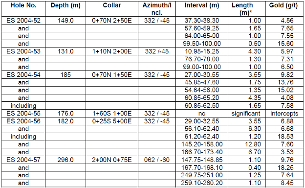
Table 2 Source: Canadian Gold Hunter Corp. news release – October 24, 2004
Figure 1: Historical Drilling on the Esker Claim
Drill Holes 13, 14, 15, 16, 17, 22 and 23 – Comaplex Minerals Corp. 1997
Drill Holes 26,27, 28, 29 and 30 - Placer Dome (CLA) Limited 2002
Drill Holes 52, 53, 54, 55, 56, 57 - Canadian Gold Hunter Corp. 2004
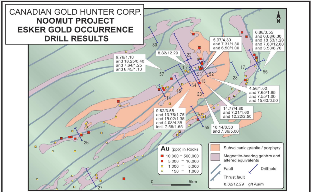
Figure 1 Source: Canadian Gold Hunter Corp. news release – October 24, 2004
The Significance of the Esker Claim
New Break targeted the Esker/Noomut claims for on-line staking due to the prolific historical exploration results on the Esker claim. When the Nunavut Map Selection System went live on January 31, 2021, the Esker claim was not available for staking. In July 2021, the Company’s diligence paid off and New Break was able to stake this significantly important claim after identifying that it had come open for staking.
New Break later learned that another private company, thinking that they were the owners of the Esker claim, had completed a sizeable exploration program on the Esker claim including:
- collection of four surface grab samples;
- locating all 18 historical diamond drill holes noted above (3,220 metres of drilling);
- collection and assaying of 18 diamond drill samples from seven of the historical drill holes, in which they found good correlation to historical drill results; and
- submission of all necessary documentation to the Nunavut Impact Review Board for the purpose of becoming fully permitted to run a drilling program on the Esker claim and on a nearby property in 2021-2022. The drilling permit was received however, no drilling was carried out.
New Break considers these events as unquestionable validation of the Company’s rationale for targeting the Esker claim and Noomut area for gold exploration, and more broadly, supportive of New Break’s views on the potential for significant exploration success within the Ennadai-Rankin greenstone belt in Kivalliq Region, Nunavut, which is also host to the Company’s Sundog, Sy and Angikuni Lake Projects.
Figure 2: Outline of Esker Claim and Outline of Area of Proposed Drilling Program
(Source: Nunavut Impact Review Board website)
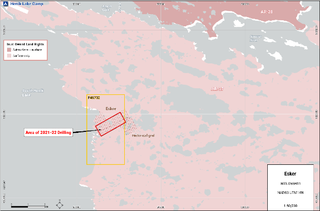
Figure 3: Area of Historical and Proposed Drilling within Esker Claim
(Source: Nunavut Impact Review Board website)
Figure 4: Esker Claim – Comaplex IP and Ground Mag Compilation
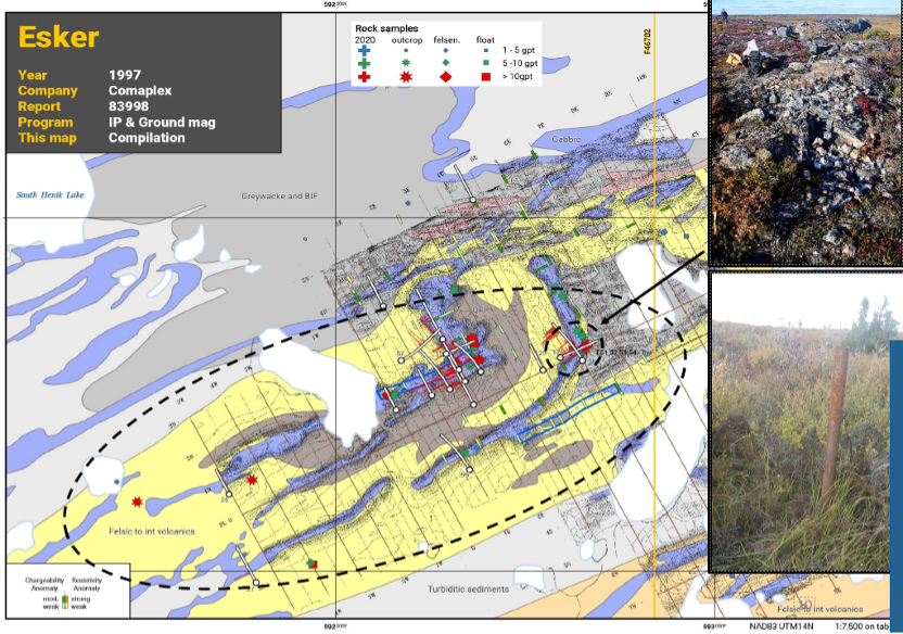
(Source: Nunavut Impact Review Board website)
Nearby Properties - Ironside and Napartok Gold Occurences (not owned by New Break)
In 1996, Comaplex conducted airborne and ground geophysical surveys covering parts of the Northern and Southern claim blocks. A helicopter‐borne airborne geophysics survey consisting of magnetics and electromagnetics (“EM”) totaled 2,930.5 line‐km. Four (4) grids were laid out in 1996 which consisted of the 3 grids that made up the Napartok gold occurrence (Napartok Central, Napartok East, and Napartok West) and the Ironside grid, which was originally established in 1995. Ground geophysics was done on all four grids which entailed a Total Field Magnetic survey along with a Horizontal Loop Electromagnetic survey (“HLEM”).
In 1997 The Napartok Central grid was extended by adding an additional 19.77 line‐km. Ground geophysical surveys were only completed at the Napartok Central grid, which included a magnetics survey totaling 19.77 line‐km, a HLEM survey totaling 9.58 line‐km and an Induced Polarization survey totaling 1.6 line‐km.
During 1996, completed a diamond drilling program which consisted of 5 holes at Ironside totaling 667 metres and 7 at Napartok totaling 926 metres. Three of the holes drilled at the Ironside gold occurrence intersected anomalous gold mineralization including hole IR96‐1, which intersected 5.75 g/t Au over 3.0 metres. Of the 7 holes drilled at the Napartok gold occurrences, 4 were drilled at Napartok Central, which yielded the best intersections including 18.3 g/t Au over 3.0 metres in hole NK96‐6 and 9.2 g/t Au over 2.5 metres in hole NK96‐7. Visible gold was present in all 7 drill-holes.
In total, between 1994 and 2002, Comaplex collected over 1,500 surface samples, 692 till samples, and 1,600 core samples from 39 drill holes in the South Henik Lake area, on and in the immediate vicinity of the Esker, Ironside and Napartok gold occurences.
In August 2011, an airborne geophysical survey, consisting of 596 line-km, was flown by Fugro Airborne Surveys Corp., which encompassed parts of the Northern and Southern claim blocks. The airborne survey flight lines were orientated north‐south with a 200-metre primary line spacing and occasional 100-metre infill lines. The helicopter‐borne geophysical survey measured magnetics and EM with a DIGHEMV multi‐coil, multi‐frequency EM system.
Geology and Mineralization
The Esker Property lies within the Ennadai-Rankin Archean greenstone belt, within the Hearne Province and Kaminak Subprovince, both of which are part of the Western Churchill geological province of the Canadian Shield. This prolific greenstone belt extends westward for over 700 km from Rankin Inlet.
The regional geology of the Esker Property area comprises Henik Group rocks, which consist of middle greenschist facies metamorphosed volcanics, sediments and intrusives. The volcanics consist of intrusive and extrusive lavas along with pyroclastics, which range in composition from ultramafic to felsic. Andesites and basalts are the main compositions, while dacites, rhyolites and gabbros can be observed in minor quantities. The sediments overlie the volcanics and are mainly composed of argillites and greywackes.
The geology of the Esker claim block comprises major parallel iron carbonate / shear / stockwork vein zones along contacts of deformed, altered gabbros.